AJ100 and VU.CITY

discover vu.city

Find out why VU.CITY is the No.1 choice of over 60% of AJ100 firms in the UK.


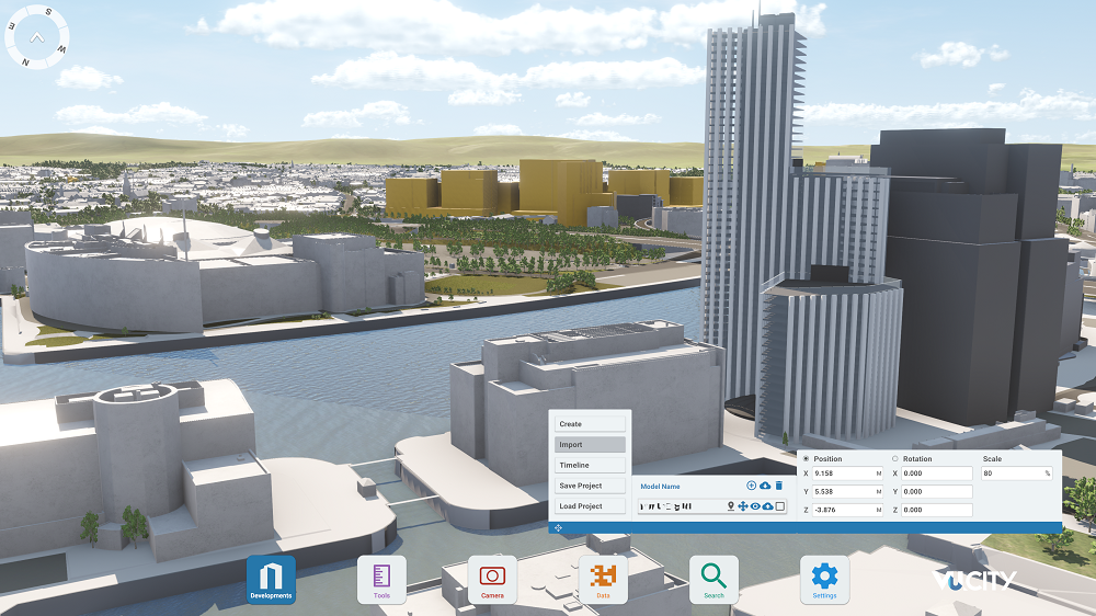
Create ideas and test them – from one building to a masterplan. Share your vision, wow clients, and move from conception to completion with confidence.

AJ100 and VU.CITY

Barr Gazetas 


See for yourself how other AJ100 architectural practices are using VU.CITY to gain a competitive edge in attracting and impressing new clients.

Click the button below to explore how architects at Barr Gazetas have used VU.CITY to streamline their workflow, embrace innovative technologies in the field of architecture and improve communication with their project stakeholders.

"VU.CITY has definitely sped up our workflow, it’s made it a lot quicker and easier and more importantly, I don’t have to spend a long time training up a part one or part two to work with me on this… we can share it with clients and explain how things work in a very legible way"

Pradnum Pamidighantam, Senior Architect, Barr Gazetas

VU.CITY and the AJ 100


VU.CITY is the choice of over 60% of AJ100 architectural firms in the UK, including Foster +Partners, BDP, Zaha Hadid Architects, Allford Hall Monaghan Morris, Sheppard Robson, Allies and Morrison to name of few. 

Why? Our platform empowers architectural firms to visualise, analyse, and simulate the built environment, supporting the pre-planning application process and expediting the usually time-consuming tasks associated with it, ultimately saving time and money.  

Future urban planning & development


With our consented timeline feature available across all of our cities,  you can visualise how your project will look in context, and be able to compare it to other approved schemes. 

Using the consented timeline feature allows you to effectively explore the evolution of the urban environment you’re working on, which enables you to make more informed decisions. You can craft designs that seamlessly blend with both present surroundings and future cityscapes. Explore significant consented schemes in their natural settings, unveiling crucial details like developers and architects. With this tool at your disposal, envisioning the urban future has never been easier or insightful.

Data visualisation

With VU.CITY, you can harness the power of data-driven decision-making with city-specific planning data layers, sourced from both public and private sectors. Instantly identify your project’s proximity to historical landmarks or conservation zones. Delve into critical factors like pollution levels and public accessibility to gain deeper insights into your scheme’s feasibility and potential impact. 

What's more, with VU.CITY, you can overlay numerous data layers on our 3D city models to analyse a site, communicate ideas and make data-driven and informed decisions. With this ability, you can understand trends, patterns and relationships in data that would be difficult or impossible to see otherwise. 

Make data the guiding force for your projects.

Collaborate


Save time and cost by collaborating with all stakeholders in one place.

VU.CITY is constantly evolving and listening to its users to better improve the platform. With the VU.CITY Hub,  project collaboration is made a seamless exercise. The hub allows you to engage with project teams, stakeholders, and planning decision-makers. Now everyone can come together and understand with the clarity that comes from being able to view and comprehend proposals in 3D.

Tell a story


Craft your project narrative in a manner that ensures complete understanding and enthusiasm from all stakeholders. Leverage the full range of capabilities our platform provides to effectively convey your vision.

You can utilise VU.CITY to narrate a compelling story and breathe life into your vision in the following ways:

1. Create a 3D Urban Environment: Use VU.CITY to build a detailed 3D model of your project or urban area. This immersive representation can vividly depict your vision.

2. Showcase Realistic Scenarios: Utilise the platform's capabilities to depict different scenarios, such as daytime and nighttime views, shadows, and urban planning alternatives. This helps stakeholders visualise the project's potential.

3. Virtual Tours: Develop virtual fly-throughs to guide stakeholders through your vision. This brings another level of understanding to your project.

4. Highlight Key Features: Use VU.CITY to emphasise critical project elements, like architectural design, green spaces, infrastructure, and transportation networks. This ensures that your vision's unique aspects are clearly communicated.

8. Interactive Presentations: Deliver dynamic presentations by interacting with the model in real time. This allows for on-the-fly adjustments and customisation to cater to various stakeholder preferences


By leveraging VU.CITY's features, you can effectively convey your vision, making it more engaging and understandable to all stakeholders, from urban planners to the general public.

Section Intro Icon

OUR USERS

Used by leading architects, both big and small

Kappie
Bennetts Associates
Foster Partners
Make
All Ford Hall Monaghan Morris
Geraghty Taylor
Hawkins Brown
BDP
Todd

Over 50 local authority users across the UK & Ireland

Dublin City Council
Belfast City Council 2015
Dacorum Council Logo
Bristol City Council grey
Cambridge City Council
Medway Council White Strapline
Salford City Council Logo

Over 90% of London's local authorities

Kingston
Tower Hamlets
City Of Westminster
Waltham Forest
Southwark

Planners at the forefront of planning technology

Turley
Tibbalods
Mobatagu Evans
Peter Stewart Consultancy
Iceni Logo
Etla
Citydesigner

Leading, forward-thinking developers and agents

Jll
Landsec
Savills
Lendlease
Canary Wharf
Taylor Wimpey
Left Arrow
Right Arrow